
DroneVision SAR - Search and Rescue Detection Platform
Design
https://www.figma.com/design/0M2kLjF1Rnzie143iVOweH/divasai?m=auto&t=p6xFRmAyt8BnfRxb-6
Overview
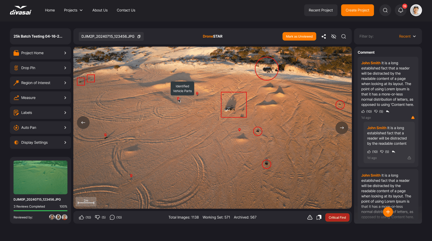
DroneVision SAR is an intelligent search-and-rescue detection system built to support emergency response teams during disaster operations. By analyzing drone camera feeds in real-time, the platform detects people, vehicles, and emergency signals such as SOS gestures - even in low-visibility environments like forests, mountains, and collapsed structures.
The system connects to a React-based command dashboard, delivering instant alerts, GPS coordinates, and visual bounding box overlays to help first responders rapidly locate survivors.
Technologies
Computer Vision & AI
- YOLOv8 Object Detection
- Custom dataset training (distressed people, vehicles, SOS)
- OpenCV, PyTorch
Platform & Integrations
- RTSP / Drone Video Stream Processing
- GPS coordinate mapping
- WebSockets for low-latency alerts
Frontend
- React, Material UI
- Real-time video overlay visualization
- Map integration (Leaflet / Mapbox)
Backend & Deployment
- FastAPI / Node.js (stream + detection management APIs)
- Docker + GPU acceleration
- Edge/Cloud compute compatibility
Features
- Real-time drone video analysis with high-precision human detection
- Distress state recognition (lying posture, motionless behavior, SOS signals)
- Search zone mapping with survivor geolocation pins
- Alert system with auto-captured images and confidence scores
- Mission dashboard for active rescue tracking
- Low-light & thermal compatibility (optional model version)
- Offline fallback mode for remote rescue missions
Development
- Created a custom-trained YOLOv8 model optimized for aerial angle detection and tiny object resolution
- Built a GPU-accelerated detection service capable of 30+ FPS
- Engineered an end-to-end streaming pipeline with reduced latency for real-time decision support
- Developed a React dashboard to display detection overlays synchronized with drone geolocation
- Implemented a modular architecture so additional object classes (e.g., debris, fire hotspots) can be added easily
Challenges
- Tiny Object Detection
- Aerial footage often shows humans at very small pixel sizes; required extensive augmentation & tuning
- Harsh Environments
- Landscape camouflage and motion blur impacted model accuracy
- Latency Constraints
- Optimization work was required to maintain reliable FPS during active rescues
- GPS-Vision Alignment
- Converting bounding box location into accurate world coordinates posed mapping challenges
Conclusion
DroneVision SAR demonstrates a high-impact application of computer vision, drones, and mission-critical UX. By enabling faster survivor detection, the platform helps rescue teams act decisively when every second matters.
This project showcases your strengths in:
✔ Real-time AI pipelines
✔ Full-stack engineering for operational technology
✔ Human-centered product design for emergency use cases